
Weather and climate
Precipitation
Precipitation occurs when the air becomes saturated with water vapour: it can hold no more. Air containing a lot of moisture is described as humid. Fully saturated air has 100% humidity. When saturated, the water vapour in the air starts to condense (turn from gas to liquid) around tiny particles in the air, such as sea salt or dust. Millions of these tiny droplets gather together to form clouds. In the highest clouds, the water freezes into ice. When the ice or water droplets become too heavy to stay up, they fall or "precipitate" to the ground as rain—or snow if the air below is freezing.


Saturation
Air may become saturated when it cools (warm air can hold more water vapour than cool air) or when more and more water vapour is added to the air. The temperature at which moist, cooling air becomes saturated and starts to condense is called the dew point. We can see this process at work when clouds form. Air cools when it rises and expands (adiabatic cooling), or when it comes into contact with a cooler surface. Water vapour becomes added to the air as a result of evaporation from oceans and lakes or transpiration from plants.
Different kinds of precipitation
Air may become saturated—either by cooling or by the addition of water vapour—in different ways, causing three different types of precipitation: frontal, convective and relief precipitation.
The sun warms different parts of the Earth’s surface by different amounts, making some regions of air warmer than others. The boundaries between these regions are known as fronts. Warm air rises over cold air at a warm front, or cold air pushes into it at a cold front. In both cases, frontal precipitation results.
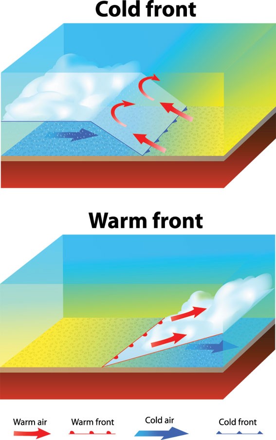
When warm air flows up and over colder, heavier air, the moisture in it condenses, causing clouds to form and rain to fall. This is a warm front, shown here as a line of red semicircles. When cold air pushes against warm air along a cold front, shown as a line of blue triangles, it forms a low wedge, bringing a narrow band of heavy rain and then cooler, fresher, showery conditions.
Convective precipitation occurs when warm, moist air is heated by the sun and rises rapidly, causing towering cumulonimbus clouds to form. Thunderstorms, producing heavy downpours, are often the result. Most precipitation in the tropics is convective.
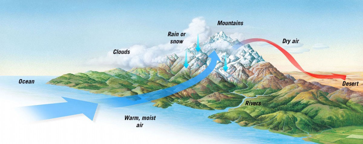
Thirdly, relief or orographic precipitation results when moist air is forced to rise over a mountain range. Where the flow of air—now emptied of water—continues over the mountains, there is much less precipitation on the other side. This is called a rain shadow. The Patagonian Desert, on the leeward side (facing away from the prevailing winds) of the Andes Mountains, is a good example of a rain shadow desert.


Freezing rain
Freezing rain is liquid droplets of rain that freeze on contact with surfaces, including the ground, trees, electrical wires, aircraft and cars. The resulting ice, called glaze ice, can accumulate to thicknesses of several centimetres and so become heavy enough to bring down tree branches or power lines. Weather systems that produce freezing rain are called ice storms. Freezing rain occurs when rain droplets fall through a layer cold air just before they hit the ground. The droplets are "supercooled", but remain in liquid form even though their temperature has fallen below zero.
Consultant: Ian Fairchild