
Oceans

CITE
We have made every effort to follow citation style rules, but there may be some minor differences. If in doubt, please refer to the appropriate citation style manual.
Ocean floor. (2026). In Q-files Encyclopedia, Earth, Oceans. Retrieved from
https://www.q-files.com/earth/oceans/ocean-floor
"Ocean floor." Earth, Oceans, Q-files Encyclopedia, 8 Jun. 2026.
https://www.q-files.com/earth/oceans/ocean-floor.
Accessed 13 Sep. 2026.
Ocean floor 2026. Earth, Oceans. Retrieved 13 September 2026, from
https://www.q-files.com/earth/oceans/ocean-floor
Earth, Oceans, s.v. "Ocean floor," accessed September 13, 2026.
https://www.q-files.com/earth/oceans/ocean-floor


Ocean floor
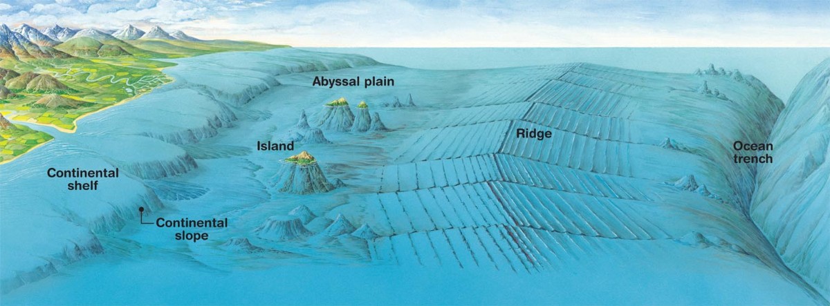
Much of the ocean seems completely empty: a great expanse of featureless water, dotted with the occasional island. But beneath the waves it is a different picture. Between 4000 and 5000 metres (13,000–16,500 feet) down lies a dramatic landscape of vast abyssal plains, jagged mountains, erupting volcanoes and deep canyons. The undersea world amounts to nearly three-quarters of the Earth's surface—the plains beneath the Pacific Ocean alone cover about the same area as all the Earth’s land put together—yet hardly any of it has been explored.

Continental shelf
The continental shelf is part of a continental landmass that lies under water. An area of shallow, sunlit waters where most ocean life is found, the shelf usually extends up 50–100 kilometres (30–60 miles) out from the shore, although the Siberian continental shelf is 1500 kilometres (900 miles) wide. Here the water is no more than 200 metres (650 feet) deep.

The continental shelf plunges steeply about 2000–2500 metres (6500–8000 feet) down the continental slope, then further down the less steep continental rise, to the abyssal plain. The steep continental slope marks the true boundary between ocean and continent.
The continental slope is usually scarred by deep canyons. These are carved by the outflow of rivers from the land. Sometimes great avalanches of water, mud and other sediments, called turbidity currents, surge down these canyons. They form fan-shaped piles of sediment on the ocean bed at the foot of the continental slope.

Abyssal plain
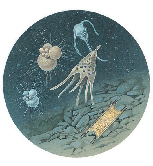
The ocean floor is mostly made up of a flat plain, called the abyssal plain. It lies at an average depth of around 4500 metres (15,000 feet). The rocky bottom is covered with a thick layer of "ooze" made of billions of skeletons of tiny animals and plants that have collected on the sea floor. The deepest parts are not covered in ooze: here there are vast areas covered with potato-sized nodules (lumps) of metal (see below) that have formed very slowly out of the sea water. Rising from the abyssal plain are mountains, volcanoes and long winding ridges. In places, deep trenches are carved into the plain.
Polymetallic nodules
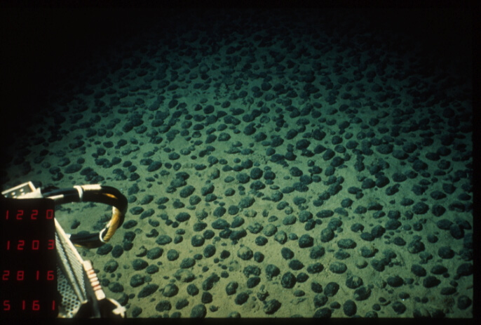
Polymetallic nodules (also called manganese nodules) are potato-shaped lumps of metal between 3 and 10 centimetres (1 and 4 inches) in diameter found on the deep ocean floor. They form when minerals in the seawater start to form a coating around a small object on the sea floor, such as a shell or stone. Over millions of years thick layers, which contain compounds of metals such as cobalt, manganese and nickel, build up. Growing demand for these metals, used in batteries for electronic devices or electric vehicles, has prompted mining companies to find ways to extract them from the ocean floor.
Seamounts
and islands
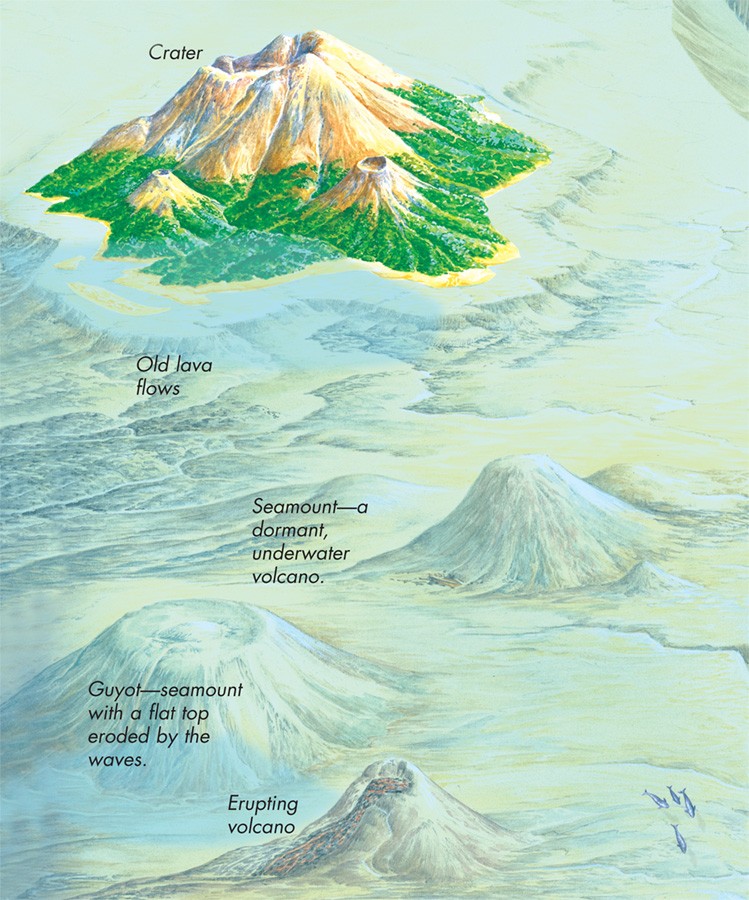
Sometimes, volcanoes erupting on the ocean floor grow large enough to poke above the ocean surface as islands. Seamounts are underwater volcanoes that do not reach the ocean surface. Guyots (pronounced JEE-ohs) are islands or seamounts with their tops eroded flat by the waves.
The world's tallest mountain from base to peak is an oceanic island: Mauna Kea on Hawaii in the Pacific Ocean, at 10,205 metres (33,620 feet)—with 6000 metres (20,000 feet) below the waves.
Abyssal plain pollution
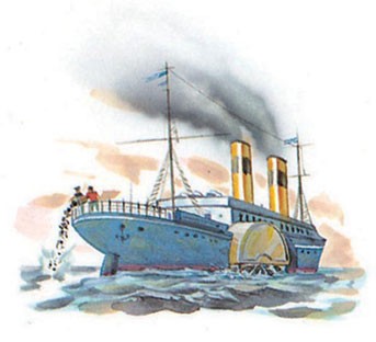
Cans, bottles, nets and rusting wrecks litter the abyssal plain. The most common kind of human rubbish found here is clinker—burnt coal dumped from steamships that plied the oceans between the 1850s and the 1950s. Clinker is concentrated beneath the main ocean shipping routes, although small fragments are found in nearly every sample of ocean floor sediments taken by scientists. It seems that every square kilometre of the ocean floor has been polluted with human rubbish.
Deep-sea trenches

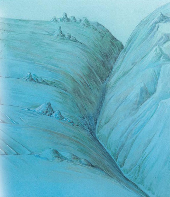
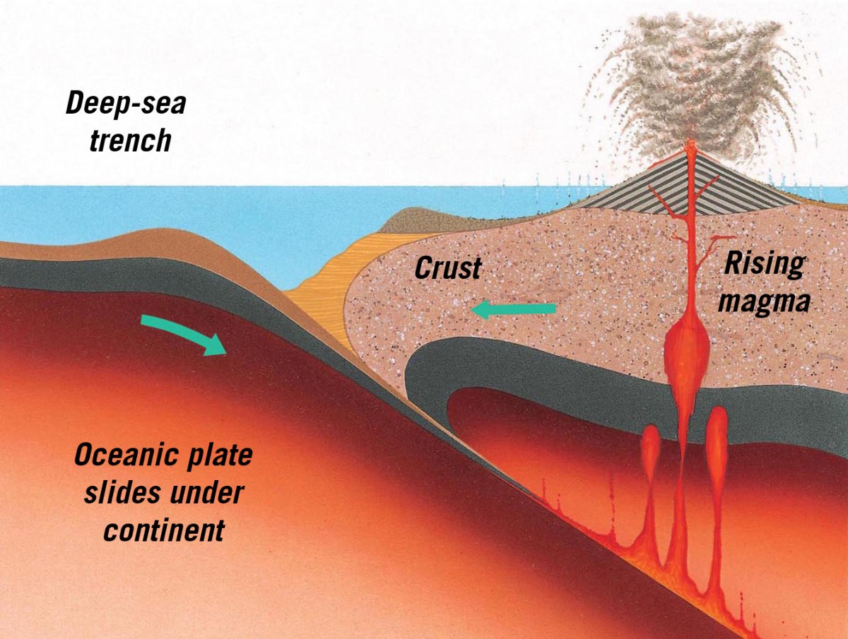
Deep-sea trenches are like gashes in the abyssal plain. The Mariana Trench, east of the Philippine Islands in the Pacific Ocean, is the deepest of all. Its deepest point is Challenger Deep, which lies 10,920 metres (35,800 feet) below the ocean surface.
Trenches occur where two of the Earth’s tectonic plates collide with one another beneath the ocean. The oceanic plate is thinner and denser than the continental one, so it slides down beneath it. The rocks of the ocean floor sink deeper and deeper into the Earth and melt. This is known as subduction.
Challenger Deep
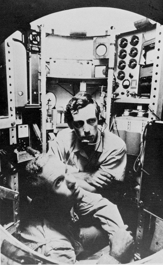
In 1960, two scientists, Jacques Piccard and Don Walsh, descended in a bathyscaphe (a kind of submersible) named Trieste almost to the bottom of Challenger Deep. The dive lasted nearly five hours. They travelled in an observation capsule attached to the underside. To withstand the enormous pressure, the walls were 13 cm (5 inches) thick.
In March 2012, the US film director James Cameron made the first solo dive to the bottom of Challenger Deep. He travelled in his "vertical torpedo" submersible, Deepsea Challenger, fitted with a robotic claw and a "slurp gun" for sucking up small sea creatures for study at the surface.
A third dive was successfully achieved in May 2019. Travelling in his 4.6-metre (15-foot) submersible DSV Limiting Factor, American explorer Victor Vescovo reached 10,927 metres (35,849 feet) beneath the ocean surface: a new record. He also discovered new species of sea creatures—but also spotted a plastic bag and sweet wrappers.
Mid-Oceanic Ridge
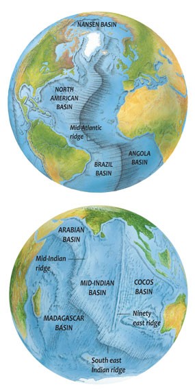
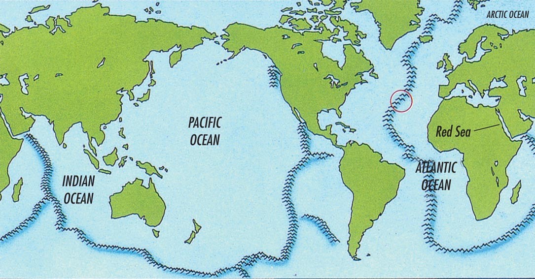
The Mid-Oceanic Ridge snakes across the ocean floor for a distance of 65,000 kilometres (40,000 miles). It starts in the Arctic Ocean and runs southwards through the Atlantic before bending to the east, winding through the Indian and Pacific Oceans. It ends up near the west coast of North America. One branch runs up the Indian Ocean and meets the Great Rift Valley in the Red Sea.
There are much longer faults cutting right across the Ridge at right-angles. These are called transform faults. They break up the sea floor into giant blocks, giving the Ridge a zig-zag shape.
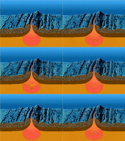
The Mid-Oceanic Ridge marks the boundary where many of the Earth’s tectonic plates are pulling apart. Here, molten rock from beneath the Earth’s crust pushes up to fill the gap in a series of undersea volcanoes. Some of the Ridge's volcanoes are 4200 metres (13,800 feet) high, but only a few break the ocean waters as islands. Iceland has grown into a large island as volcanoes have erupted over and over again in the same place.

Sea-floor spreading
New ocean floor is gradually being formed along the Mid-Oceanic Ridge, where magma erupts from beneath the crust, cools rapidly under the water and solidifies. It is a continuous process, adding to the edges of the plates as they push further and further apart. Every year, the crack running down the Ridge grows wider by a few centimetres—about the speed that fingernails grow. Over millions of years the ocean floor itself becomes wider and wider. This is called sea-floor spreading.
Undersea volcanoes
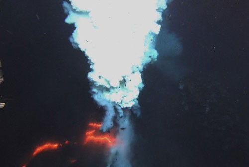
Volcanoes are not just on land: many are under the seas and oceans. The majority of underwater volcanoes are near areas of tectonic plate movement, along the Mid-Oceanic Ridge. Unlike the violent explosions of some land volcanoes, the eruptions along the Ridge are fairly gentle. This is because the liquid rock flows easily. Along the centre of the Ridge runs a rift valley, a strip of land between two parallel faults. Most of the eruptions happen here, where magma finds its way to the sea floor through the faults.
In some places along this valley, water seeping down into the rocks is heated by the hot magma. It shoots back up through cracks in the ocean floor, known as hydrothermal vents. Black smokers are dark, rocky chimneys, several metres high, found near hydrothermal vents.

Black smokers emit warm, mineral-rich water from beneath the Earth’s crust and attract an amazing variety of ocean life. Vents have been discovered in various locations on ocean floors, at an average depth of 2100 metres (about 7000 feet).
Consultant: Ian Fairchild
pics
Without in any way limiting Q-files Ltd’s exclusive rights under copyright, any use of this publication to “train” generative artificial intelligence (AI) technologies to generate text is expressly prohibited. Q-files Ltd reserves all rights to license use of this work for generative AI training and development of machine learning language models.