
Famous inventors

CITE
We have made every effort to follow citation style rules, but there may be some minor differences. If in doubt, please refer to the appropriate citation style manual.
John Harrison. (2026). In Q-files Encyclopedia, Technology, Famous inventors. Retrieved from
https://www.q-files.com/technology/famous-inventors/john-harrison
"John Harrison." Technology, Famous inventors, Q-files Encyclopedia, 16 Mar. 2026.
https://www.q-files.com/technology/famous-inventors/john-harrison.
Accessed 7 Aug. 2026.
John Harrison 2026. Technology, Famous inventors. Retrieved 7 August 2026, from
https://www.q-files.com/technology/famous-inventors/john-harrison
Technology, Famous inventors, s.v. "John Harrison," accessed August 7, 2026.
https://www.q-files.com/technology/famous-inventors/john-harrison


John Harrison
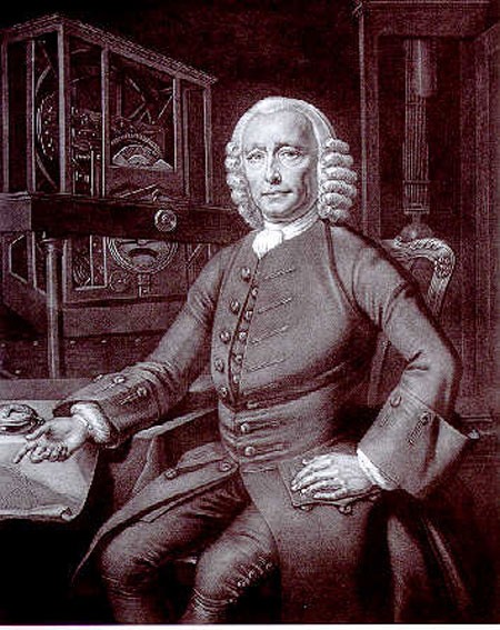
John Harrison (1693–1776) was an English clockmaker. He had decided to enter a competition for the Longitude Prize, announced by the British Government in 1714. The prize would be given to whoever found a method of accurately plotting the East-West position, or longitude, of a ship at sea. Born in Foulby, Yorkshire, Harrison's family moved to Lincolnshire while he was still a boy. He became a clockmaker, designing and building precision clocks with a high degree of accuracy. He planned to win the prize by inventing a clock that kept time at sea to the same accuracy as those he had already designed.


Measuring longitude
As long-distance sea travel became increasingly common in the late 17th and early 18th century, it became more and more important for sailors to be able to accurately determine their position at sea, in order to pinpoint their exact position on a map and avoid hazards, such as reefs and shallow water. Finding latitude—how far north or south they were—was no problem, as that could be easily established by measuring the height of the Sun in the sky. But longitude was much more difficult to work out.
Latitude and longitude
Lines of latitude, running east-west, circle the globe from pole to pole. They allow a north-south position on the Earth's surface to be fixed. The line of latitude that runs around the Earth's middle, halfway between the poles, is the Equator: it is 0° latitude. Places to the north have latitude positions anywhere between 0 and 90°N; places to the south of the Equator have latitude positions anywhere between 0 and 90°S.


Lines of longitude, running north-south, divide up the globe by degrees of a circle, allowing an east-west position on the Earth's surface to be fixed. The line of longitude that runs through Greenwich is the Prime Meridian of the world: it is 0° longitude. Places to the east of the Meridian have longitude positions anywhere between 0 and 180°E; places to the west of it have longitude positions anywhere between 0 and 180°W.
The problem
of longitude
To determine the longitude of any location, it was first necessary to know the local time by observing the position of the stars or Sun. If this time could then be compared with the exact time in another location—at Greenwich in London, for example—then a ship's navigator could work out how far east or west of that line of longitude they were currently positioned. For every 15° of longitude travelled east (or west), the local time moved one hour ahead (or back). So if the local times at two points on Earth were known, the difference between them could be used to work out how far apart those places were in degrees longitude.

The problem was that knowing the time in Greenwich meant having a clock that could reliably keep time on a long, rough sea journey from England. Although reasonably accurate pendulum clocks existed since their invention by Christiaan Huygens in 1656, the motions of a ship prevented them from keeping accurate time at sea.
The search for a solution

King Charles II of Great Britain founded the Royal Observatory at Greenwich in 1675 in order to solve the problem of calculating longitude at sea by astronomical observation. If the positions of the stars could be accurately catalogued, and the position of the Moon calculated relative to those of the stars, then the Moon could be used as a natural "clock" to work out what the time was at a reference point, Greenwich. Navigators would then know the local times at two different locations, and so calculate their longitudinal position. This was known as the Lunar Distance Method.
Progress on establishing the Lunar Distance Method was slow, however. So, in 1714, the British Government offered £20,000 for an alternative method to plot longitude at sea to within half a degree (about two minutes of time). A Board of Longitude was set up to judge the prize.

Harrison's first designs
John Harrison entered the competition, believing he could build a clock that could keep time accurately at sea and so give a ship's navigators an accurate longitude reading. His first attempt (later called H1) was a portable version of a precision clock he had designed previously. The moving parts were controlled and counterbalanced by springs, rather than a pendulum which could not have worked on board a ship that rocked from side to side. It was tested aboard a ship in 1736; it performed well, but not well enough for Harrison's exacting standards.
Harrison's second and third designs (H2 and 3), produced over the course of the next 19 years, incorporated an ingenious escapement mechanism. This released the tooth of a gear, which moved the gearwheel forwards until the opposite arm struck another tooth on the gear, which locked it again. The gearwheel was connected to various cogs which turned the hands on the timekeeper. Despite improvements, however, the designs failed to achieve the accuracy specified by the Board of Longitude. Harrison now realised that a solution to the longitude problem required an entirely different design.


H4
1755 Harrison discovered that a new pocket watch he had had made for his personal use could, with a few improvements, be an excellent timekeeper. The result was what came to be known as H4: a timekeeper completely different from his earlier designs. It looked like a large watch. On a two-month voyage to the West Indies 1761, the watch was found to have lost only 5.1 seconds.
The accuracy of H4 was much better than required to win the £20,000 Longitude Prize, but the Board of Longitude would not be satisfied unless other devices could be tested to the same degree of accuracy. Harrison would be paid the first half of the prize, £10,000, once he had disclosed the workings of H4 to a panel of experts—which he duly did, with some reluctance. In order to qualify for the second half of the prize, Harrison had to make at least two more watches and have them tested.
Success
John Harrison and his son William worked on a fifth timekeeper (H5), but still the Board was not satisfied. So Harrison, now 79 years old, appealed to King George III, who witnessed a successful demonstration of H5 himself in 1772. Harrison was finally awarded the second half of the Longitude Prize by Parliament in 1773.
In the meantime, Captain James Cook had set out on his second voyage of discovery. He had a copy of H4 on board and it performed brilliantly, never losing more than eight seconds daily. John Harrison died almost a year after Cook's return, on 24th March 1776 at the age of 83. Cook's voyage proved beyond doubt that longitude could be measured accurately from Harrison's timekeeper.


Consultant: Dave Hawksett
pics

Without in any way limiting Q-files Ltd’s exclusive rights under copyright, any use of this publication to “train” generative artificial intelligence (AI) technologies to generate text is expressly prohibited. Q-files Ltd reserves all rights to license use of this work for generative AI training and development of machine learning language models.